September saw the first edition of
The Accretionary Wedge, which I took part in. However, I wasn't able to write anything for the second one. The subject of the third edition caught my attention. "Geology and Life", aka "Between a Rock and a Squishy Face" to be hosted by
The Other 95%. After I thought about it I decided not to write about
my thesis topic. I have just started writing my thesis yesterday and could use a break. Well, technically I haven't start, but instead spent time getting
emacs/
auctex just right and
rsync working for daily backups (aka wasting time). I promise I will start tomorrow. ;-)

Anyways, I thought of another subject that would be perfect and I have an interest. Zoogeomorpholgy is the study of the impacts of animals on the landscape. Man is the most obvious geomorphic agent. Some of our actions are only important on short temporal scales of our perspective, but others will surely be found in the geological record in the future. Removal of natural vegetation cover increases erosion resulting in an larger sediment fluxes entering oceans [1]. Anthropogenic climate change will also have an influence on geomorphology. However, for this I want to focus on non-human animals. A comprehensive review of this subject is available in the book
Zoogeomorphology by
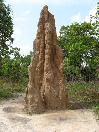
David Butler [2]. Termite mounds, crayfish burrows (>40,000 kg per hectare), birds ingesting sediment for use in their gizzards, animal paths to salt licks, and rabbit holes are only a sampling of geomorphic roles animals can play. I am going to focus on American Beavers (Castor canadensis) and Gray Whales (Eschrichtius robustus).

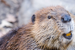
Beavers use mixtures of wood and mud to make dams across streams to create ponds. These dams vary greatly in size, with largest dam reported at 652 m long, although they are more typically tens of meters in length [1]. They can store large amounts of sediment. Researchers examining streams in a Quebec, Canada, found that an average size single dam could store 6,000 cubic meters of sediment [3]. Over a watershed of hundreds of square km, this could be on the magnitude of hundreds of thousands. Using estimations of pre-European contact beaver numbers, sediment stored behind beaver dams in North America is greater than
100 billion cubic meters [4]. After dams are abandoned, the ponds often form new valley floors.
In terms of hydrology, beaver dams also raise the local water table. Finally, dam burst can cause extreme floods, greatly affecting stream morphology. Butler reported a dam burst that increased flow 1000 times over normal rates and moving 1 m granite rocks. This flood ended up killing four people. A dam burst in the Sierra Nevada Mts in California resulted in a dramatic drop in local base level and an associated .5 m of stream channel incision [5].

One of the more surprising examples of zoogeomorphology is the action of Gray Whale (Eschrichtius robustus) feeding. They winter near Baja California, but migrate to the Chukchi and Bering Seas between Alaska and Siberia during the Arctic summer. This is the longest mammalian migration in the world. In the Arctic sea, they feed on benthic crustaceans, or those that live in or on the sea floor. Using their mouths, gray whales scoop sediment from the sea-bottom. The sediment filtered via
baleen, although some is ingest along with crustaceans. This filtered sediment is released near the surface in plumes. Off the California coast, researchers found that in areas of only a few square km, gray whales moved hundreds of tons of sediment [6]. In the Bering Sea, it has been calculated that 120 million cubic meters of sediment is moved by gray whales every year. This is
3 times the annual load of the Yukon River, that also empties into the sea [2].
References: [1]: Walling, D.E. (2006). Human impact on land–ocean sediment transfer by the world's rivers.
Geomorphology 79:192-216.
[2]: Butler, D. (1995).
Zoogeomorphology. Animals as Geomorphic Agents. Cambridge University Press.
[3]: Naiman, R., Melillo, J., Hobbie, J. (1986). Ecosystem Alteration of Boreal Forest Streams by Beaver (Castor Canadensis).
Ecology 67:1254-1269.
[4]: Butler, D., Malanson, G. (2005). The geomorphic influences of beaver dams and failures of beaver dams.
Geomorphology 71:48-60.
[5]: Kondolf, G., Cada, G., Sale, M., Felando, T. (1991). Distribution and stability of potential salmonid spawning gravels in steep boulder-bed streams of the eastern Sierra Nevada.
Transactions of the American Fisheries Society 120:177-186.
[6]: Cacchoine, D., Drake, D., Field, M., Tate, G. (1987). Sea-floor gouges caused by migrating gray whales off northern California.
Continental Shelf Research 7:553–560.
Image Sources:Termite mound:
Litchfield Park - Termite Mound by
Daryl FritzBeaver:
Beaver by
Tancread Gray Whale:
Gray Whale by
NMFS

 Anyways, I thought of another subject that would be perfect and I have an interest. Zoogeomorpholgy is the study of the impacts of animals on the landscape. Man is the most obvious geomorphic agent. Some of our actions are only important on short temporal scales of our perspective, but others will surely be found in the geological record in the future. Removal of natural vegetation cover increases erosion resulting in an larger sediment fluxes entering oceans [1]. Anthropogenic climate change will also have an influence on geomorphology. However, for this I want to focus on non-human animals. A comprehensive review of this subject is available in the book Zoogeomorphology by
  Beavers use mixtures of wood and mud to make dams across streams to create ponds. These dams vary greatly in size, with largest dam reported at 652 m long, although they are more typically tens of meters in length [1]. They can store large amounts of sediment. Researchers examining streams in a Quebec, Canada, found that an average size single dam could store 6,000 cubic meters of sediment [3]. Over a watershed of hundreds of square km, this could be on the magnitude of hundreds of thousands. Using estimations of pre-European contact beaver numbers, sediment stored behind beaver dams in North America is greater than 100 billion cubic meters [4]. After dams are abandoned, the ponds often form new valley floors.
  One of the more surprising examples of zoogeomorphology is the action of Gray Whale (Eschrichtius robustus) feeding. They winter near Baja California, but migrate to the Chukchi and Bering Seas between Alaska and Siberia during the Arctic summer. This is the longest mammalian migration in the world. In the Arctic sea, they feed on benthic crustaceans, or those that live in or on the sea floor. Using their mouths, gray whales scoop sediment from the sea-bottom. The sediment filtered via


