Posted by Chris M Monday, December 29, 2008
Map Monday #6: Seismicity Cross Section
As previously shown many times on the geoblogosphere, the USGS's earthquake site is a good site for recent and occurring earthquakes. While looking through the site I saw on November 24, 2008 at 09:02 UTC, a 7.3 magnitude quake happened in the Sea of Okhotsk, off the west coast of Kamchatka. Under the "seismic cross section" there is a great map illustrating the variation in quake depth at subduction zones. The November 24 quake was deep focus at a depth of 491 km, well into the Wadati-Benioff zone. The map shows the increasing depth of foci from the boundary, as the subducting plate moves deeper into the mantle.
Map Information
Seismic Cross Section for Magnitude 7.3 Sea of Okhotsk at
Monday, November 24, 2008 at 09:02:58 UTC. Preliminary Earthquake Report U.S. Geological Survey, National Earthquake Information Center World Data Center for Seismology, Denver.
Posted by Chris M Monday, December 22, 2008
Map Monday #5: Worldwide Glaciation
On this week's map Monday, it is back those hotbeds of early geologic research, glaciers and the Alps. Unlike the previous map that focused on glaciation in the Alps, this attempted to combine the presently known evidence of glaciation to produce a world wide map. The map includes inserts showing greater detail in the Alps, North American, and the south island of New Zealand. The largest maps are polar projections of both the north and south poles. Once again, the map is from the David Rumsey collection.
Map Information
Eisverbreitung, einst und jetzt. Polar Ansicht der Erde in Lambert's flachenrechter Azimuthal-projection . (with) Der Rhein-Gletscher nach A. Favre. (with) Der Rhone Gletscher nach A. Falsan. (with) Seen-Gebiet in Nord-Amerika nach Chamberlin und Wright. (with) Die Europaischen Alpen. (with) Iseo-Gletscher nach Stroppani. (with) Der Loisach- und Inn-Gletscher n. Penck & Bayberger. (with) Die Sudlichen Alpen (Neu-Seeland) nach J. v. Haast. Entw. v. Herm. Berghaus 1884, Ausg. 1886. Gotha: Justus Perthes (1892)
Posted by Chris M Thursday, December 18, 2008
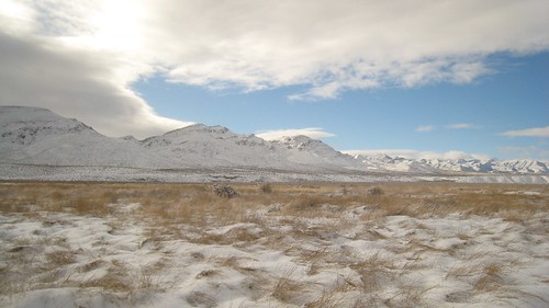
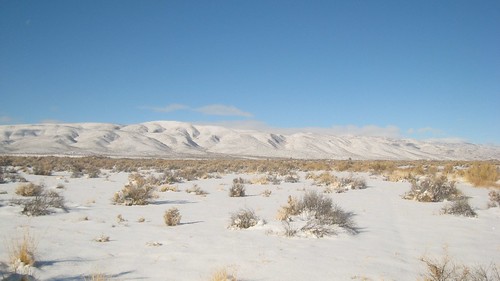
Snow on the valley floor
The week saw a couple of storms with very low snow levels, down to some Mojave valley floors. Even Las Vegas got 3.6 in of snow, the most since 1979! Now, some places in Nevada do get snow (it is the name), but it is unusual for my location. In my own neck of the
The back end of the storm system this morning.
That isn't salt in the foreground.
One Northern Shoveler and several American Coots gather in the only ice free part of a pond.
Posted by Chris M Monday, December 8, 2008
Map Monday #4: Mercator's North Pole
Gerardus Mercator was a pretty influential cartographer. In fact, when most people think of a map of the world, they think of Mercator's projection (for better or worse). One of Mercator's accomplishments was his 1595 posthumously published atlas, Atlantis pars altera.
As you would expect from a map from 1595 there are some major issues. His northern America has no connection with reality, Greenland is smaller, and an island (Frisland) has appeared between Iceland and Greenland. What is most interesting his his depiction of the geographic north pole and his two magnetic north poles. The below is Mercator describing the geographic north pole and one of the magnetic north poles.
In the midst of the four countries is a Whirl-pool . . . into which there empty these four indrawing Seas which divide the North. And the water rushes round and descends into the earth just as if one were pouring it through a filter funnel. It is four degrees wide on every side of the Pole, that is to say eight degrees altogether. Except that right under the Pole there lies a bare rock in the midst of the Sea. Its circumference is almost 33 French miles, and it is all of magnetic stoneMercator's other magnetic north pole is located in the present day Chukchi Sea north of the Bering Strait.
Map Information
Septentrionalium Terrarum descriptio from Atlantis pars altera. Mercator, Gerhard. 1595.
Posted by Chris M Tuesday, December 2, 2008
Titan Cryovolcanism
Little did I know yesterday, but Titan is also the subject of this month's planetary geomorphology image of the month from the IAG. The image shows cryovolcanism on the surface of Titan, particularly Ganesa Macula, a possible shield volcano. Cryovolcanoes are like their counterparts on earth, except they erupt "cold" materials such as water or ammonia.
Posted by Chris M Monday, December 1, 2008
Map Monday #3: Titan Topography
I am a little late with this week's map because I spent the holiday backpacking in Death Valley, which is evidently the place you spend your first Nevada Thanksgiving.
So the first two weeks have been 19th century maps. Why not something much more recent? The above image are elevations of Titan (on of Saturn's moons) obtained by the Cassini space probe in 2007. The top half is a radar scan of part of Titan's north pole. This has been converted into a DEM and transformed into a topographic image of elevations on the bottom half. You really need to click on the image to get a good view.
Subscribe to:
Posts (Atom)